Category:De Krakeling, Keistraat
Jump to navigation
Jump to search
| Object location | | View all coordinates using: OpenStreetMap |
|---|
house in Utrecht, Netherlands  | |||||
| Upload media | |||||
| Instance of | |||||
|---|---|---|---|---|---|
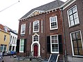
| Location | Utrecht, Netherlands | ||||
| Street address |
| ||||
| Located on street | |||||
| Heritage designation |
| ||||
 | |||||
|
This is a category about rijksmonument number 35993
|
| Address |
|
Media in category "De Krakeling, Keistraat"
The following 21 files are in this category, out of 21 total.
-
 Achter Sint Pieter 50.JPG 3,456 × 2,592; 4.39 MB
-
 De Krakeling hoek Keistraat Utrecht RM35993.jpg 2,048 × 3,072; 3 MB
-
 De Krakeling Utrecht RM35993.jpg 3,072 × 2,048; 3.05 MB
-
 De Krakeling Utrecht.JPG 480 × 640; 143 KB
-
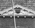 Detail gevel - Utrecht - 20235384 - RCE.jpg 1,200 × 956; 285 KB
-
 Detail interieur schildering - Utrecht - 20235391 - RCE.jpg 951 × 1,200; 147 KB
-
 Detail voorgevel - Utrecht - 20235386 - RCE.jpg 1,200 × 956; 294 KB
-
 Gevel - Utrecht - 20235385 - RCE.jpg 972 × 1,200; 250 KB
-
 Gevel - Utrecht - 20235387 - RCE.jpg 961 × 1,200; 244 KB
-
 Ingang - Utrecht - 20235389 - RCE.jpg 866 × 1,200; 268 KB
-
 Interieur - Utrecht - 20235393 - RCE.jpg 954 × 1,200; 166 KB
-
 Interieur - Utrecht - 20235395 - RCE.jpg 1,200 × 956; 178 KB
-
 Interieur detail - Utrecht - 20235392 - RCE.jpg 963 × 1,200; 194 KB
-
 Neude Janskerkhof en Domplein, Utrecht, Netherlands - panoramio (45).jpg 2,048 × 1,155; 585 KB
-
 Neude Janskerkhof en Domplein, Utrecht, Netherlands - panoramio (48).jpg 1,155 × 2,048; 594 KB
-
 Neude Janskerkhof en Domplein, Utrecht, Netherlands - panoramio (80).jpg 4,896 × 3,264; 3.23 MB
-
 Overzicht hoekpand - Utrecht - 20235377 - RCE.jpg 894 × 1,200; 250 KB
-
 Overzicht van de ingangspartij in de voorgevel - Utrecht - 20383839 - RCE.jpg 1,200 × 1,198; 288 KB
-
 Schampalen en schampsteen in de Keistraat te Utrecht.jpg 522 × 384; 152 KB
-
 Voorgevel - Utrecht - 20235388 - RCE.jpg 874 × 1,200; 227 KB
-
 Voorgevel - Utrecht - 20235390 - RCE.jpg 869 × 1,200; 228 KB


.jpg)
.jpg)
.jpg)


